Project Overview
Jump To Section of Page
The project has developed out of the need to replace Landing Road Bridge due to the fact that the current bridge is structurally deficient and functionally obsolete. The existing Landing Road Bridge, a two-span concrete arch structure built in the early 1900’s, was determined to be individually eligible for listing on the New Jersey and National Registers of Historic Places in 1994. The bridge has been recognized as a key contributing resource to Morris Canal Historic District, listed on the New Jersey and National Registers. Although the original bridge has historical significance and has provided many years of continuous service, it has deteriorated over the years and presently has numerous structural and safety deficiencies which warrant its replacement. In order to meet current highway and bridge safety standard and improve the operation of the adjacent intersection, the project will replace the current bridge with a wider and safer and structurally sound bridge; one able to meet current standards for traffic safety and load carrying capacity for many years to come. It will also widen and improve the existing roadway and sideways and reconfigure the intersection of Mt. Arlington Blvd. and Lakeside Dr.
The major challenge of this project is to replace the bridge and upgrade the roadway and intersection while meeting the needs of the various community stakeholders. Two important factors in achieving this objective are minimizing impact to the traveling public and incorporating aesthetic elements into the project to evoke the character the original structure, as well as, the former Morris Canal and Historic Lake Hopatcong Station.
Existing Bridge/Roadway Description
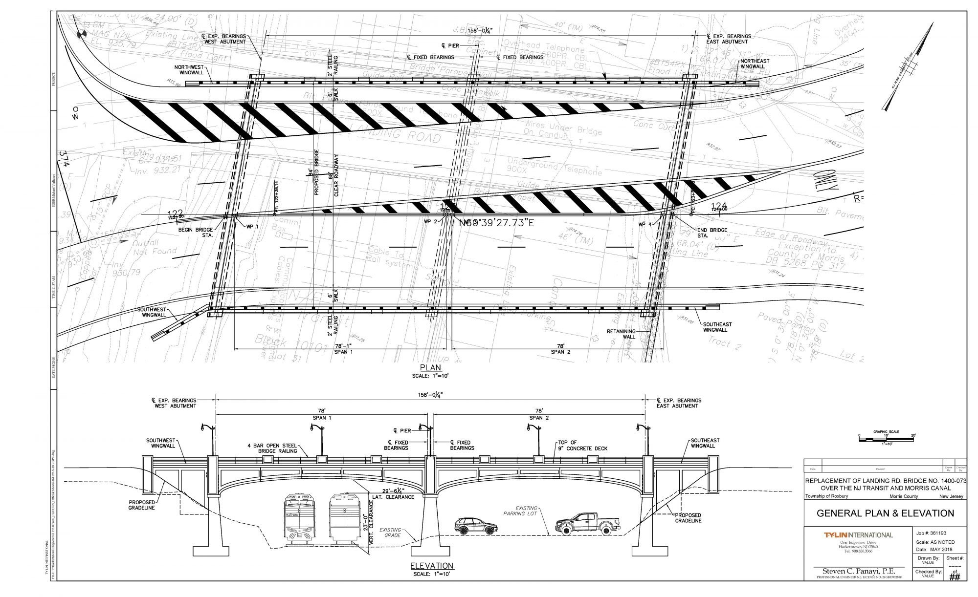
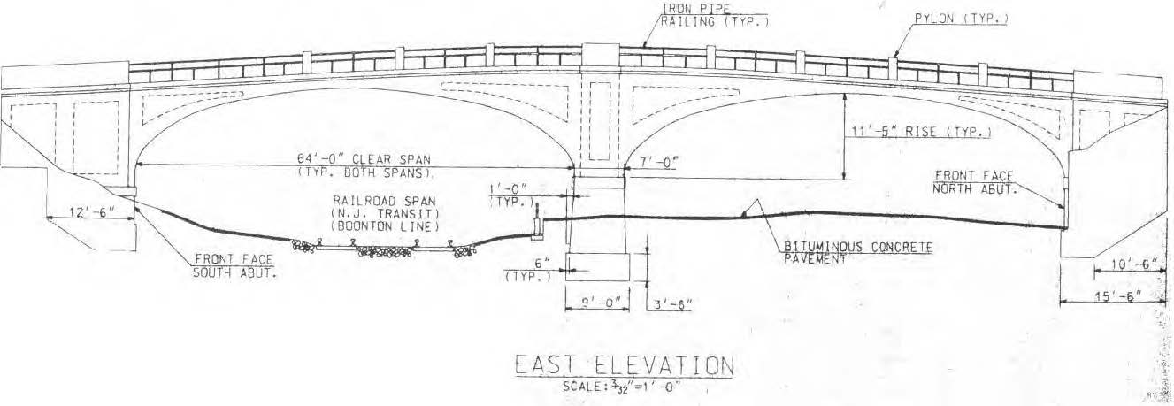
The existing bridge, Landing Road over NJ Transit (Structure No. 1400-073), is a Morris County-owned bridge located in the Township of Roxbury. The structure carries County Route 631 (Landing Road) over the dual track NJ Transit Montclair-Boonton Line and the former Morris Canal, which is currently a parking lot serving the NJ Transit’s Lake Hopatcong Station. The bridge, constructed circa 1907, is a twin-span, reinforced concrete, closed spandrel arch with earth fill. It is the earliest example of this bridge type (closed spandrel concrete arch with earth fill) in Morris County, as well as the only twin-span example in existence in Morris County.
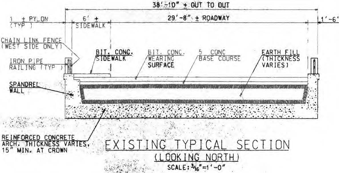 The existing structure carries two lanes of east and west bi-directional traffic and one sidewalk across the NJ Transit Tracks. The bridge is 136 feet long, has a curb-to-curb width of 28′-9” and has a 5’-9” sidewalk along the north side. The bridge has a bituminous concrete (asphalt) wearing surface over a concrete base course. The existing minimum vertical under-clearance over the railroad tracks is 20’-11”, which does meet the current standard of 23’-0”. The clear span under each arch is 64’-0” and provides for sufficient horizontal clearance for both tracks.
 The bridge was itself determined to be individually eligible for listing on the New Jersey and National Registers of Historic Places in 1994 and is a key contributing resource to the New Jersey- and National Register-listed Morris Canal Historic District, as well as the Old Main Delaware, Lackawanna & Western Railroad Historic District. As such, removal of the bridge does not comply with the Secretary of the Interior’s Standards for the Treatment of Historic Properties and, therefore, minimization and mitigation of effects to the Morris Canal is required. An extensive multi-year process involving the County, the County’s Consultants, Stakeholder Groups and NJSHPO have resulted in a consensus of mitigation measures to be incorporated into the design and construction of the project. These measures are enumerated in Memorandum of Agreement Issued by the NJDEP in accordance with the resolution adopted by the Historic Sites Council.
Historic Mitigation
Pursuant to a letter from NJDEP Natural and Historic Resources dated April 28, 2016, concurring with and adopting the resolution of the Historic Sites Council passed on April 22, 2016 the project must meet five Mitigating Conditions, which are generally as follows:
- Design of the replacement bridge and associated project elements shall be finalized in consultation with the NJ Historic Preservation Office (HPO), the Roxbury Historic Advisory Committee, Landing Gateway Committee, Canal Society of New Jersey and other interested parties.
- Prior to demolition, existing conditions and setting of the bridge shall be documented according to the standards of the Historic American Engineering Record (HAER).
- Develop and install interpretive signage outlining the history of Landing, focusing on the Morris Canal, railroads and bridges at the site.
- Develop an archaeological treatment plan and ensure that it is implemented. As detailed in the April 28th letter, the plan includes archaeological monitoring and archaeological survey at specific locations, and provisions for ways to avoid, minimize or mitigate adverse effects to historic resources.
- Incorporate the mitigating conditions into the contract documents, including plans and specifications, and submit to HPO for review.
The project team will work hand in hand with our Cultural Resources subconsultant, RGA, to ensure the replacement bridge and roadway elements are compatible to the maximum extent possible with the historic and architectural character, significance and setting of the Historic District and evoke the character of the existing bridge.
Existing Roadway Conditions
Utilities within the project limits include aerial electric distribution, telephone and cable facilities supported on utility poles immediately adjacent to the north fascia of the bridge and across the approach roadways at each side of the structure. Relocation of approximately six poles and associated aerial facilities is anticipated. In addition, aerial electric lines are present within the railroad right-of-way (ROW) crossing below the bridge which will need to be relocated to facilitate demolition and construction operations.
Underground utilities include subsurface telephone conduits extending to riser poles which will be relocated to accommodate the location of the riser poles associated with the aerial relocations. There are subsurface telephone facilities located below the pavement box within the infill of the existing arch structure that will need to be relocated prior to demolition work.
Landing Road (C.R. 631) is classified as a Minor Urban Arterial and generally travels north and south in a curvilinear manner between Route I-80 to the south and its northern terminus at the signalized intersection with Lakeside Boulevard and Mount Arlington Boulevard at the southern end of Lake Hopatcong. Just south of the Landing Road Bridge, while travelling in a northerly direction, Landing Road curves sharply to the right and crosses the bridge in an east-west direction before terminating at the Lakeside Boulevard and Mount Arlington Boulevard intersection. From this intersection, Lakeside Boulevard continues to the north while Mount Arlington Boulevard continues to the south. In the immediate vicinity of the bridge, the horizontal alignment is tangent, and the vertical alignment is a crest curve with relatively steep grades. The average daily traffic (ADT) is approximately 23,000, of which truck traffic is approximately 4%. The posted speed limit is 35 miles per hour.
Proposed Bridge Description
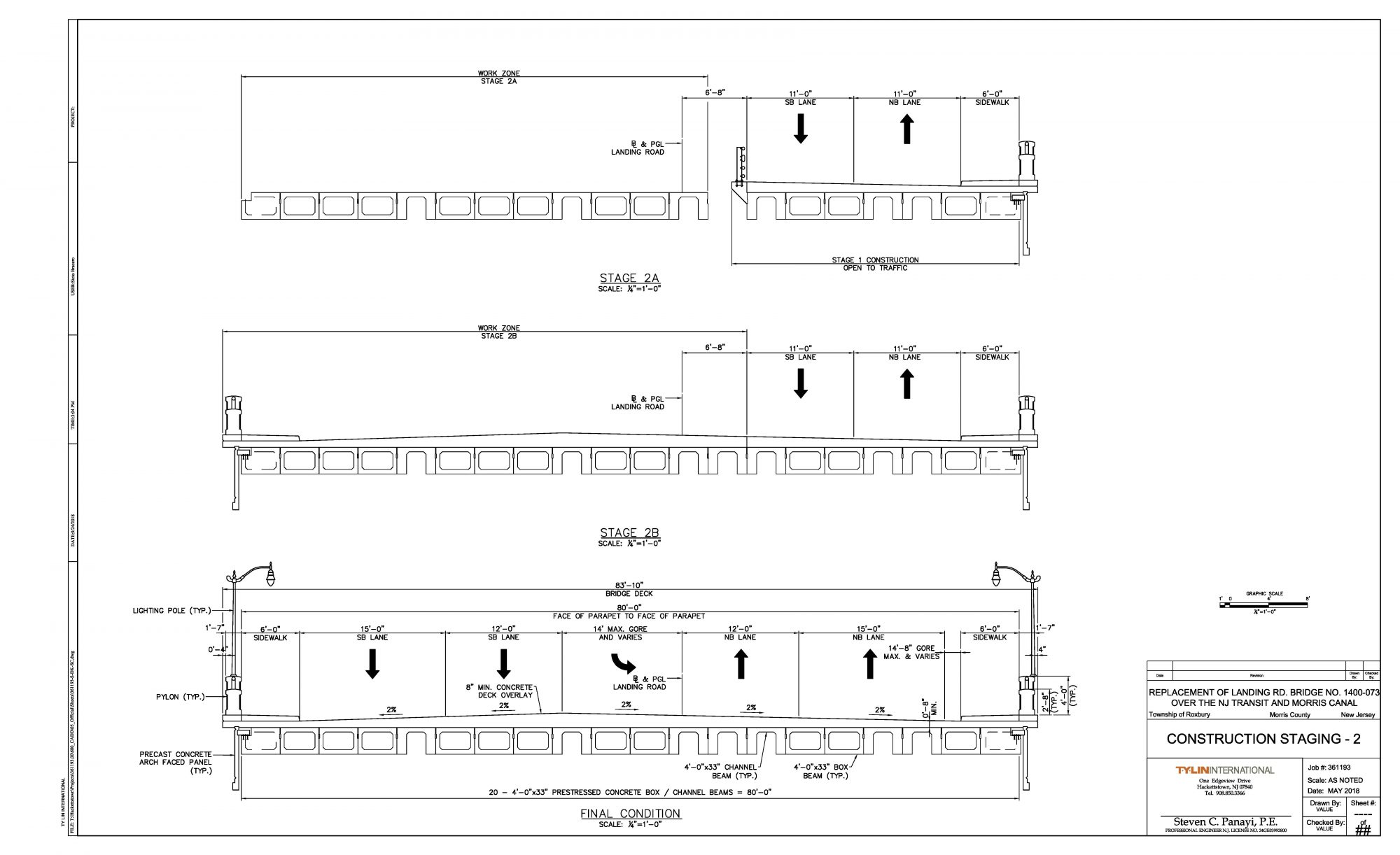
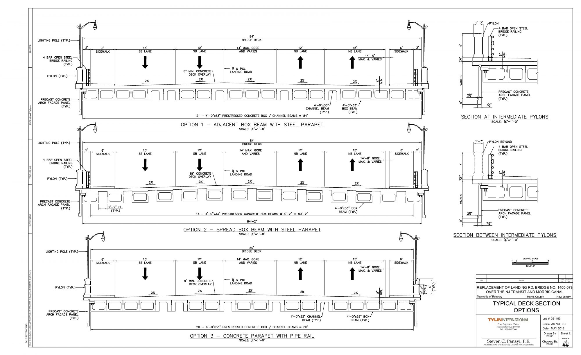
The replacement bridge will be in accordance with Alternative 7C of the Scoping Study, which includes replacement of the bridge with a new wider structure carrying four lanes and two sidewalks, situated on a shifted and rotated alignment that improves traffic operations including the Lakeside Boulevard/Mt. Arlington Boulevard Intersection and reflects the aesthetics of the existing structure.
 One of the project challenges will be to develop a superstructure type that is reminiscent of the shape and appearance of the existing bridge to the greatest extent possible while meeting the project needs and adheres to the site constraints and clearance requirement of the NJ Transit Railroad located below the bridge.
Proposed Roadway and Intersection
The proposed roadway will consist of 2 – 12 ft. inner traffic lanes and 2 -15 ft. (bicycle friendly) outer traffic lanes. Which will allow for 2 – thru lanes in each direction. There will also be a signal protected center turning lane in each direction at the main intersection between Landing Road and Mt. Arlington Blvd./Lakeside Drive. The intersection will be realigned from a “T” intersection to a 4 way intersection. This improved geometry will allow for a straight through movement (instead of a left turn) in order to stay on Lakeside Drive. It will also realign the access to the NJ Transit Train Station to be aligned with Mt. Arlington Boulevard and be a signalized movement. Signalization will also be provided at Kings Highway with pedestrian cross walks and 6 ft sidewalks on both sides of the roadway throughout both intersections. The sidewalk along Lake Hopatcong at the retaining wall will be widened and the top of the wall and fence will be reconstructed. Overall the construction will provide for Improved roadway geometry , greater safety, improved operation and Improved Level of Service at the intersections.

Project Schedule
- 2019 Complete Supplemental Survey, Geotechnical Investigation, LSRP Investigation
- 2019 Submit Permits
- 2019 Prepare ROW Documents
- 2019/2020 Complete Final Design
- 2019/2020 Acquire ROW
- 2020 Prepare Bid Documents
- 2020/2021 Award Contract/Begin Construction
- 2022/2023 Complete Construction
Other Considerations
A major factor that will affect the selection of the bridge superstructure type and the design of the roadway vertical profile is the required vertical under-clearance over existing NJ Transit Montclair-Boonton Line tracks. As per AREMA Section 2.4.2 and NJDOT Design Manual Table 2.3.3.2, the minimum vertical clearance over tracks shall be 23’-0” for the new construction. The existing minimum clearance is 20’-11” in the northeast quadrant of the bridge, as noted in the 2013 inspection report, which does not meet this requirement. In addition, all of the lateral clearance requirements of AREMA and NJ Transit must also be met and existing operations both on the track side and in the public parking/station area be maintained.
Based on the NJ Transit train schedule for the Montclair-Boonton Line, there is no scheduled passenger train traffic between 11:51 p.m. and 5:33 a.m., and there is no passenger train traffic on weekends. This provides an opportunity for nighttime and weekend outages without disrupting normal commuter traffic. Some of the bridge construction operations will need to take advantage of these windows of time to perform certain operations in close proximity to the track.
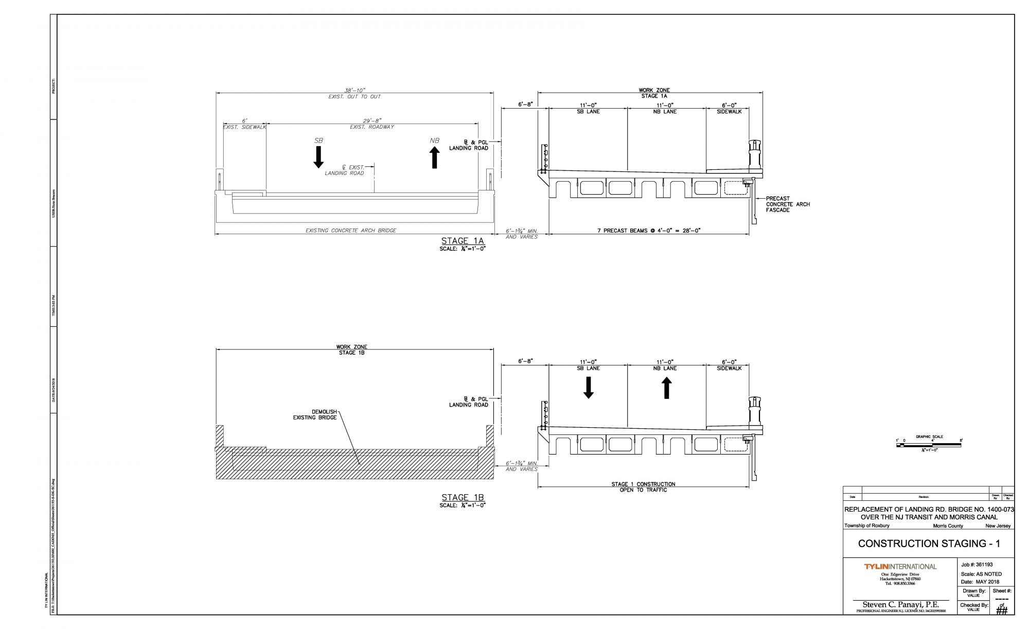
The intent of the project is to maintain at least two lanes of traffic (one in each direction) during the construction phase. The existing bridge is a filled arch type structure, therefore partial width demolition is not advisable. In light of this, the existing bridge will need to remain in service during Stage 1 of the construction when half of the proposed bridge (2 lanes and a sidewalk) will be constructed offline.